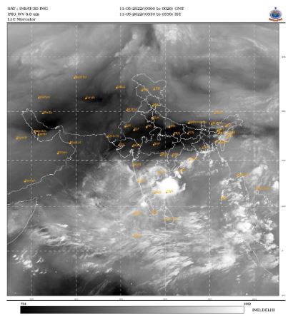
The Severe Cyclonic Storm ‘Asani’ (pronounced as Asani) over westcentral Bay
of Bengal moved west-northwestwards with a speed of 12 kmph during past 06 hours,
weakened into a Cyclonic Storm and lay centered at 0230 hours IST of 11th May, over
same region near latitude 15.6°N and longitude 81.3°E, about 60 km south-southeast of
Machilipatnam (Andhra Pradesh), 180 km south-southwest of Kakinada (Andhra
Pradesh), 310 km southwest of Visakhapatnam (Andhra Pradesh), 550 km southsouthwest of Gopalpur (Odisha) and 660 km southwest of Puri (Odisha).
It is very likely to move nearly northwestwards for the next few hours and reach Westcentral Bay of Bengal close to Andhra Pradesh coast. Thereafter, it is very likely to recurve slowly north-northeastwards, move along Machilipatnam, Narsapur, Yanam,
Kakinada, Tuni & Visakhapatnam coasts and emerge into west-central Bay of Bengal off North Andhra Pradesh coasts by today evening. Then it is likely to move northeastwards towards the northwest Bay of Bengal. It is likely to weaken gradually into a
depression by 12th May morning.

India Meteorological Department (Ministry of Earth Sciences)
The cyclonic storm is under the continuous surveillance of Doppler Weather Radar
(DWR) at Machilipatnam (Andhra Pradesh).
Forecast track and intensity are given in the following table:
Date/Time(IST) Position (Lat. 0N/ long. 0E), Maximum sustained surface
wind speed (Kmph), Category of cyclonic disturbance
11.05.22/0230 15.6/81.3 80-90 gusting to 100 Cyclonic Storm
11.05.22/0530 16.1/81.4 75-85 gusting to 95 Cyclonic Storm
11.05.22/1130 16.5/81.8 70-80 gusting to 90 Cyclonic Storm
11.05.22/1730 16.8/82.3 60-70 gusting to 80 Cyclonic Storm
11.05.22/2330 17.1/82.8 50-60 gusting to 70 Deep Depression
12.05.22/1130 17.5/83.6 40-50 gusting to 60 Depression
Warnings:
(i) Rainfall
11th May: Light to moderate rainfall at most places with heavy to very heavy rainfall at a few
places with isolated extremely heavy falls is likely over coastal Andhra Pradesh and heavy
rainfall at isolated places is likely over coastal Odisha & adjoining coastal West Bengal.
12th May: Light to moderate rainfall likely at a few places with heavy rainfall at isolated places
is likely over coastal areas of Odisha and West Bengal.
(ii) Wind warning
Gale wind speed reaching 80-90 kmph gusting to 100 kmph is prevailing around the system
center over Westcentral Bay of Bengal. It would gradually decrease become 60-70 Kmph
gusting to 80 Kmph by today evening over the same region. Further, it would decrease to
40-50 Kmph gusting to 60 Kmph over Westcentral Bay of Bengal on 12th May.
Squally wind speed reaching 55-65 kmph gusting to 75 kmph is prevailing along and off
Andhra Pradesh coast. It is likely to increase and become gale wind speed reaching 70-80
kmph gusting to 90 kmph in the morning hours of 11th May along & off Andhra Pradesh
coast (Krishna, East & West Godavari, Yanam of Puducherry UT and Visakhapatnam
districts) and further, it would decrease to 45-55 Kmph gusting to 65 Kmph over the region.
Squally wind speed reaching 40-50 kmph gusting to 60 kmph is likely to continue along & off
Odisha coast and West Bengal coast on 11th to 12th May.
(iii) Sea condition is likely to be high over west-central & adjoining northwest Bay of Bengal on
11th May and very rough to rough over the same region on 12th May. (iv) Storm Surge warning (Graphics enclosed)
Storm surge of height about 0.6 m above astronomical tide is likely to inundate low lying areas
of Krishna, East & West Godavari, Yanam of Puducherry UT and Vishakhapatnam districts of
Andhra Pradesh. (iv) Fishermen Warning (Graphics enclosed)
Total suspension of fishing operations over westcentral Bay of Bengal on 11th and over
northwest Bay of Bengal till 12th May.
Fishermen are advised not to venture into westcentral Bay of Bengal along and off Andhra
Pradesh and Odisha coasts on 11 th May and into Northwest Bay of Bengal till 12 th May.
Fishermen out at sea are advised to return to coast.
(v) Advisory for offshore activities
Regulate offshore operations till 12th May.
(vi) Damage expected: (for Krishna, East & West Godavari, Yanam of Puducherry UT and
Vishakhapatnam districts of Andhra Pradesh)
Damage to thatched huts.
Minor damage to power and communication lines due to breaking of tree branches.
Major damage to Kutcha and minor damage to Pucca roads.
Damage to paddy and other standing crops, banana, papaya trees and orchards
Inundation of low lying areas
(vii) Action Suggested: (for Krishna, East & West Godavari, Yanam of Puducherry UT and
Vishakhapatnam districts of Andhra Pradesh)
Stay in safe places
Check for traffic congestion on your route due to heavy rain before leaving for your
destination.
Follow any traffic advisories that are issued in this regard.
Avoid going to areas that face the water logging problems often.
The system is under continuous surveillance and the next bulletin will be issued at 0830
hours IST of today, the 11 th May, 2022.
(Ananda Kumar Das)
Scientist-E, RSMC, New Delhi